Many adventurers dream of standing on the roof of the world, but the first step in any successful expedition is understanding where is Mt Everest on the global map. This colossal peak represents the ultimate physical challenge for mountaineers and holds deep spiritual significance for the local populations, yet its precise location often confuses travelers. Grasping the geography is crucial not just for trivia, but for anyone considering a trek to Base Camp or simply wanting to comprehend the sheer scale of our planet. By the end of this article, readers will understand the political borders, the geological forces at play, and how to navigate this remote region.
Quick Geography Reference
- Exact Summit Coordinates: 27°59′17″N 86°55′31″E.
- Political Border: Bisects the international border between Nepal (Sagarmatha Zone) and China (Tibet Autonomous Region).
- Continent: Asia (Himalayan Range).
- Elevation: 8,848.86 meters (29,031.7 feet) as per the 2020 joint survey.
Geographical Location of Mount Everest
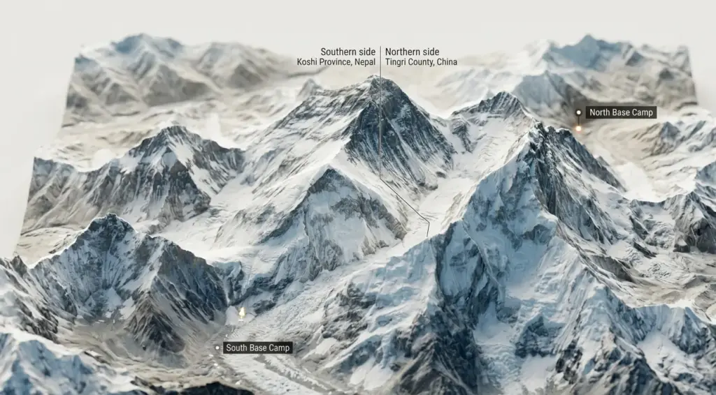
Mount Everest is positioned exactly on the international border between Nepal and China. Specifically, the southern part of the mountain lies within the Solukhumbu District of Koshi Province (formerly the Sagarmatha Zone) in Nepal. The northern section is situated in Tingri County within the Shigatse Prefecture of the Tibet Autonomous Region, China.
The Himalayas: Home of Mount Everest
The Himalayas form a massive crescent-shaped mountain range stretching across five countries. This range acts as a physical barrier separating the Indian subcontinent from the Tibetan Plateau. When pinpointing the summit’s exact position, the answer lies deep within the Mahalangur Himal sub-range of the Himalayas. This specific section boasts some of the highest altitudes on the planet, creating a dense cluster of peaks that rise above 8,000 meters. The geological violence that created these giants continues today, as tectonic plates push against each other, slowly raising the mountains higher every year.
- Primary Range: The Great Himalayas
- Sub-Range: Mahalangur Himal
- Tectonic Plates: Indian and Eurasian
To understand the scale, imagine a wall of rock and ice that disrupts global weather patterns. A traveler looking for where is mt everest located will find it nestled among other 8,000-meter giants, creating a unique microclimate.
Recent river-capture research combining river-erosion modeling with GPS measurements suggests Mount Everest is currently rising on the order of ~2 millimeters per year, with erosion-driven uplift adding to ongoing tectonic forces. (2024, University College London & China University of Geosciences (Beijing))
Coordinates and Altitude
Precision matters when discussing a landmark of this magnitude. The peak sits at the coordinates 27°59′17″N 86°55′31″E. For decades, the official height was a subject of debate, but recent surveys have settled the numbers. Knowing where is mt everest vertically is as important as its horizontal position because the air pressure at the summit drops to about one-third of sea level pressure.
Nearby Major Landmarks
Everest does not stand alone; it is surrounded by a family of giants. Lhotse, the fourth highest mountain in the world, connects to the main peak via the South Col. Nuptse forms a massive wall to the southwest. When you investigate the topography of the Mahalangur Himal, you will see the peak is flanked by these other formidable peaks, creating a spectacular amphitheater known as the Western Cwm. Trekkers often use iconic landmarks like Kala Patthar to view the summit, as the top is sometimes obscured by Nuptse when viewed from Base Camp.
Proper acclimatization is not just a suggestion but a biological necessity; ignoring the body’s need to adjust to the altitude found at these coordinates is the leading cause of evacuation.
Mount Everest in Which Country
This mountain is unique because it serves as a natural wall between two sovereign nations. This creates distinct climbing cultures, routes, and administrative rules depending on which side a climber approaches.
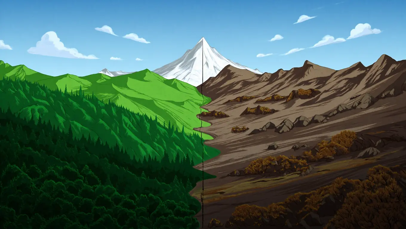
Nepal: Southern Face of Everest
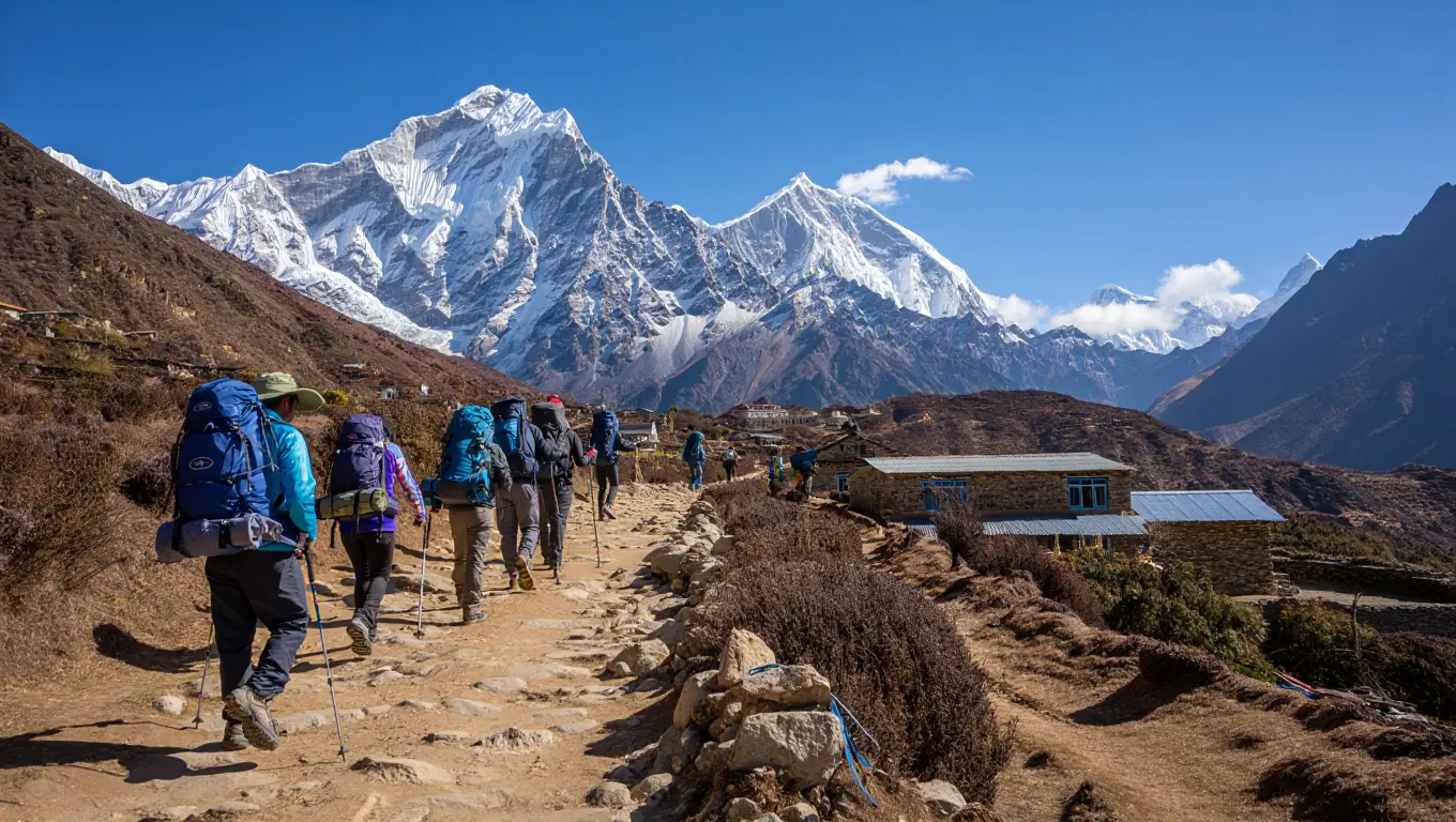
Most western climbers and trekkers associate the mountain with Nepal. The Sagarmatha National Park, a UNESCO World Heritage site, protects the region on the southern side. When wondering mount everest in which country is most popular for tourism, Nepal takes the lead due to the fame of the trek to the South Base Camp. The approach starts with a flight to Lukla, followed by a multi-day hike through Sherpa villages like Namche Bazaar.
From an administrative perspective, the approach through Nepal is governed by the Khumbu Pasang Lhamu Rural Municipality. This local authority, located in the Solukhumbu District, manages the specific trekking permits and local infrastructure that support the thousands of visitors entering the Sagarmatha National Park annually.
Step-by-Step Guide to the Nepal Approach
- Arrival: Fly into Kathmandu and secure the necessary permits (Sagarmatha National Park Entry Permit and Khumbu Pasang Lhamu Rural Municipality Entrance Permit).
- Access: Take a domestic flight to Tenzing-Hillary Airport in Lukla.
- Acclimatization: Trek to Phakding and then proceed to Namche Bazaar for a mandatory rest day.
- Ascent: Continue the hike through Tengboche, Dingboche, and Lobuche.
- Destination: Reach Gorakshep, the final settlement, before hiking to Base Camp.
For a traveler deciding mount everest in which country to visit, the Nepalese side offers a deep cultural immersion into Sherpa life that is less accessible elsewhere.
China: Northern Face and Tibetan Plateau
The northern face belongs to the Zhaxizong Township of Tingri County. Unlike the remote trails in Nepal, this region is integrated into the Chinese national highway system via the G318 Friendship Highway, which allows for vehicle access directly to the North Base Camp area under the jurisdiction of the Shigatse Prefecture.
This side offers a starkly different experience, characterized by a high-altitude desert landscape. If one asks mount everest in which country allows you to drive all the way to Base Camp, the answer is China. The North Col route is the standard path here. It is generally windier and colder than the south side, but it avoids the treacherous Khumbu Icefall.
Determining where is mt everest located politically is vital for visa applications. Accessing the north side requires a Chinese visa and a separate Tibet Travel Permit, which can be more complex to obtain than the visa on arrival available in Nepal.
Understanding where is Mt Everest located requires looking at the specific administrative divisions of Koshi Province in Nepal and Tingri County in China’s Tibet Autonomous Region.
| Feature | Nepal Side (South) | China Side (North) |
| Province/Region | Koshi Province | Tibet Autonomous Region |
| District/County | Solukhumbu District | Tingri County |
| Local Authority | Khumbu Pasang Lhamu | Zhaxizong Township |
| National Park | Sagarmatha National Park | Qomolangma National Nature Preserve |
International Border Dynamics
The summit itself is the precise border line. A climber standing on the absolute peak has one foot in Nepal and one foot in China. This geopolitical reality means that mount everest in which country an expedition starts in dictates the currency used, the language spoken, and the rescue infrastructure available.
Occasionally, political tensions can close one side of the mountain. A savvy traveler researching where is mt everest must also research current diplomatic relations. Understanding mount everest in which country provides the most stability for a specific season is a key part of expedition planning. Furthermore, knowing where is mt everest located along this sensitive border explains the strict regulations on drone usage and satellite phones.
Choosing Your Side: A Comparison
Deciding where to go depends on specific goals. Here is a breakdown of the differences between the two faces.
| Feature | Nepal Side (South) | China Side (North) |
| Access | Trekking (approx. 8-12 days) | Driving (paved road to Base Camp) |
| Primary Hazard | Khumbu Icefall | High winds and cold exposure |
| Base Camp Altitude | 5,364 meters (17,598 ft) | 5,150 meters (16,900 ft) |
| Views | Summit often blocked by Nuptse | Full view of the North Face |
| Crowds | Very busy, crowded tea houses | Regulated, fewer independent trekkers |
Always verify the current visa regulations for both Nepal and China at least six months in advance, as border policies in this region can change abruptly without warning.
What Continent is Mount Everest In
Zooming out from national borders, it is essential to look at the broader continental context. The mountain is the crown jewel of the world’s largest landmass.
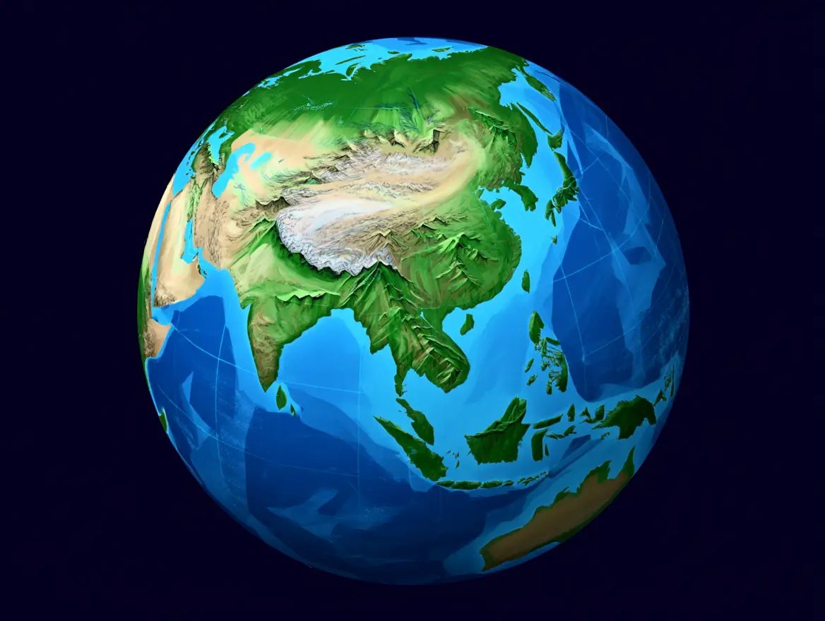
Asia: The Continent of Giants
It should come as no surprise that the highest peak sits in Asia. When a student asks what continent is mount everest in, they are identifying the landmass that contains the majority of the world’s highest mountains. The collision of the Indian tectonic plate with the Eurasian plate created the Himalayas. This ongoing geological event is unique to the Asian continent. No other continent possesses a range that rivals the height and density of the Himalayan peaks.
Understanding what continent is mount everest in provides context for the sheer scale of the landscape. The infrastructure, while improving, contends with the most rugged terrain on Earth.
Significance of the Asian Continent
Being in Asia means the mountain is subject to the Asian Monsoon. This weather system dictates the climbing seasons. The heavy rains in summer dump snow at high altitudes, making climbing dangerous. Asking what continent is mount everest in helps explain why the primary climbing windows are strictly in May (pre-monsoon) and sometimes October (post-monsoon). The mountain also acts as a “water tower” for Asia, feeding river systems that support billions of people.
When considering where is mt everest located, one must realize it is the hydrological apex of the continent. The following table compares Everest with other continental summits to highlight the unique challenges found in Asia.
| Feature | Mount Everest (Asia) | Aconcagua (South America) | Denali (North America) |
| Height | 8,848m (29,031 ft) | 6,961m (22,837 ft) | 6,190m (20,310 ft) |
| Oxygen at Summit | ~33% of sea level | ~40% of sea level | ~42% of sea level |
| Primary Challenge | Extreme altitude (Death Zone) | Physical endurance | Extreme cold & latitude |
| Support Style | Heavy Sherpa support | Mules to base camp | Self-supported sleds |
This comparison illustrates that knowing what continent is mount everest in implies preparing for the “Death Zone,” a phenomenon less prevalent on other continents. The Asian giant stands in a league of its own regarding hypoxia.
Other Major Peaks in Asia
To understand the scale, one must compare it to its neighbors. The top 100 highest mountains on Earth are all located in Asia. If a climber were to ask what continent is mount everest in and then look for K2 or Kangchenjunga, they would find them on the same landmass. K2 lies in the Karakoram range, while Kangchenjunga sits between Nepal and India. This concentration of altitude makes Asia the global hub for high-altitude mountaineering.
The Hindu Kush Himalaya Assessment reports that the region is warming faster than the global average and warns that continued warming will accelerate glacier loss—raising risks for long-term water security downstream. (2019, ICIMOD)
Travelers asking what continent is mount everest in are also asking about the future of global water security.
Cultural and Historical Significance
The mountain is far more than rock and ice; it is a sacred entity for the people living in its shadow and a history book of human endurance.
Everest in Sherpa Culture
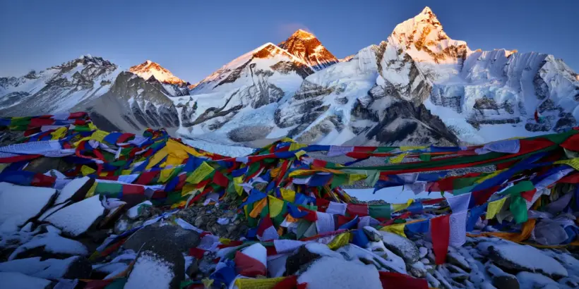
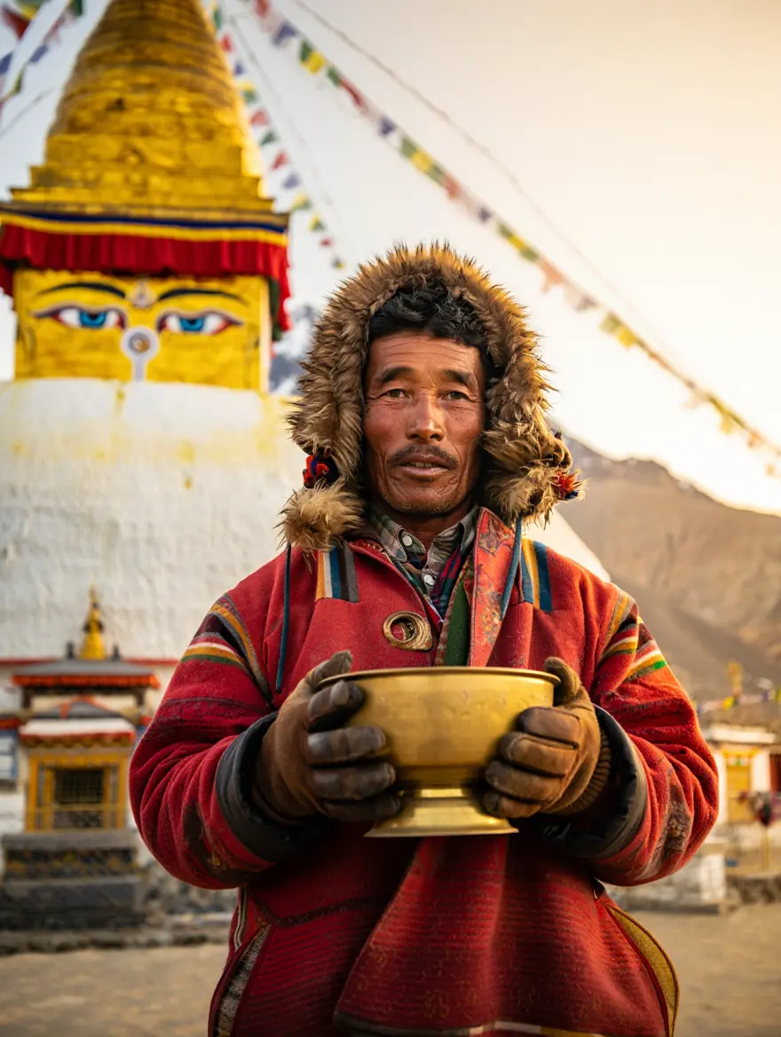
To the Sherpa people, the mountain is known as Chomolungma, meaning “Goddess Mother of the World.” They believe the mountain is the abode of Miyolangsangma, a Buddhist goddess of inexhaustible giving. Climbing is not just a sport; it is a traverse through sacred ground. When researching where is mt everest, one discovers it is the center of Sherpa spirituality.
“Before I step on her body, I bow and ask forgiveness.” — Kami Rita Sherpa, Nepali Sherpa mountaineering guide and world-record holder for the most Mount Everest summits. (BBC World Service, 2019)
Before any expedition begins, Sherpa guides and climbers perform a Puja ceremony to ask the mountain for safe passage. This ritual highlights mount everest in which country the spiritual connection is most visible—Nepal. However, the Tibetans on the north side hold the mountain in equal reverence.
Historical Expeditions and Achievements
The quest to map the peak began in 1847 during the Great Trigonometrical Survey of India. It was Radhanath Sikdar, an Indian mathematician, who first identified it as the highest point in the world (then labeled as Peak XV). It was later renamed in 1865 to honor Sir George Everest, the former Surveyor General of India, despite his own objections. The history of climbing changed forever on May 29, 1953, when Sir Edmund Hillary and Tenzing Norgay Sherpa stood on the summit.
If you’re new to Everest history, it helps to see the mountain through the lens of route planning and the human story behind modern expeditions. The video below gives a clear overview of how climbers approach the peak and why the classic routes became “standard.” It’s a solid visual companion to the geography sections above.
Understanding where is mt everest located historically helps one appreciate the equipment limitations of the early pioneers.
Impact on Local Communities
Tourism has transformed the Khumbu region. The influx of foreigners asking mount everest in which country they can trek has built schools, hospitals, and infrastructure. However, it has also shifted the local economy away from agriculture and trade solely toward tourism. Young Sherpas face pressure to work in the dangerous high-altitude industry.
The question of mount everest in which country generates the most revenue is complex, but the impact on local lives is undeniable on both sides. Investigating where is mt everest located reveals a landscape where ancient traditions meet modern commercialism.
Environmental and Climatic Conditions
The environment on Everest is hostile to life. It is an ecosystem defined by extreme cold, high radiation, and thin air.
Weather Patterns on Mount Everest
The weather is dominated by the jet stream. In winter, hurricane-force winds scour the summit, making it unclimbable. Ambient temperatures on the summit frequently hover between -20°C and -35°C during the May window, but wind chill factors from the jet stream can push perceived temperatures below -60°C, causing frostbite on exposed skin in under 60 seconds. When researching where is mt everest located for a climb, one looks for the “weather windows” when the jet stream moves north, usually in May.
These windows allow winds to drop below 30 mph, giving climbers a brief opportunity to push for the summit. Knowing what continent is mount everest in explains the monsoon influence that closes the mountain in summer.
Environmental Challenges and Conservation
Decades of commercial climbing have left a mark. The mountain has been called the “world’s highest garbage dump.” Old tents, oxygen bottles, and human waste do not decompose in the freezing temperatures. This reality is a dark side to the mountain’s global fame.
A peer-reviewed study of the South Col Glacier found that surface ice that took nearly 2,000 years to form has been stripped away within just the last few decades as the glacier thins rapidly under warming and stronger solar radiation. (2022, University of Maine)
Impact of Climate Change
Global warming is hitting the Himalayas hard. Glaciers are receding, exposing old bodies and making icefalls more unstable. This rapid melt changes the answer to where is mt everest located in terms of safety; routes that were safe ten years ago are now prone to rockfall.
Never underestimate the mountain based on someone else’s success story; conditions on Everest change by the minute, and what was safe yesterday may be lethal today.
Understanding what continent is mount everest in helps travelers grasp why the region is warming faster than the rest of the globe.
Travel and Tourism Information
One does not have to be an elite mountaineer to experience the mountain. Trekking to Base Camp is a feasible goal for fit hikers.
Popular Trekking Routes and Base Camps
The most famous route is the Everest Base Camp (EBC) trek in Nepal. It takes about 12 days round trip from Lukla. Determining mount everest in which country to visit often comes down to hiking preference. The Nepal side is steep and green, while the Tibet side is dry and flat.
Essential Preparation Checklist
To successfully reach the area where is mt everest located, one must ensure every item on this list is checked.
- Permit Check: Ensure all documents, including the TIMS card and national park permits, are sealed and valid.
- Gear Check: Boots must be broken in weeks before the flight; blisters can end a trek.
- Health Check: Vaccinations should be current, and dental work must be completed to avoid pressure-induced tooth pain.
- Insurance: The policy must explicitly cover helicopter extraction up to 6,000 meters.
- Cash: ATMs are rare in the mountains, so bringing sufficient local currency is mandatory.
If a traveler asks mount everest in which country offers a cultural trek, Nepal is the answer. If they ask mount everest in which country offers a driving tour, it is China.
Best Time to Visit Mount Everest
While climbers aim for May, trekkers have a broader window. October is famous for crystal clear skies. Knowing what continent is mount everest in allows travelers to avoid the Asian Monsoon rains. Spring brings blooming rhododendrons, making the lower valleys beautiful.
However, knowing where is mt everest geographically helps one understand why winter trekking is possible but brutally cold. The question of what continent is mount everest in is also a question of seasonal timing.
Safety Tips for Climbers and Trekkers
Altitude Sickness (AMS) is the biggest killer for trekkers. It can strike anyone.
- Hydrate: Drink 3-4 liters of water daily.
- Go Slow: The Sherpa saying is “Bistari, bistari” (slowly, slowly).
- Medication: Consult a doctor about Diamox.
Travelers asking where is mt everest located must also ask where the nearest medical facility is (usually Periche or Lukla). Knowing mount everest in which country provides the best rescue options is critical; Nepal has a robust private helicopter industry, while China does not.
A peer-reviewed study by clinicians affiliated with the Himalayan Rescue Association found that rapid ascent (e.g., reaching high altitude from low elevation in under ~48 hours) was associated with a significant increase in altitude-illness cases—supporting the point that many severe incidents are preventable with slower ascent and better acclimatization. (2017, Himalayan Rescue Association)
Unique Facts and Trivia About Mount Everest
Beyond the geography and routes, the mountain is full of bizarre and fascinating details that make for great conversation.
Record-Setting Climbs
People constantly push the limits. There are records for the fastest ascent and the oldest climber. These feats highlight what continent is mount everest in—a continent that draws the most ambitious humans.
- Kami Rita Sherpa: Holds the record for most summits.
- Lhakpa Sherpa: Holds the record for most summits by a woman.
- Jordan Romero: Youngest summiter.
Each record adds to the lore of where is mt everest.
Flora and Fauna in the Everest Region
You might think nothing lives there, but you would be wrong. The Himalayan jumping spider has been found at elevations up to 6,700 meters.
- Birds: The Bar-headed Goose flies over the summit.
- Plants: Mosses grow at high altitudes.
These biological facts add depth to the answer of where is mt everest located. Even at the extremes of what continent is mount everest in, life finds a way.
Unusual Stories and Anecdotes
The mountain has seen weddings at the summit and even a helicopter landing.
“Getting to the top is optional. Getting down is mandatory.” — Ed Viesturs, American high-altitude mountaineer (widely known for summiting all 14 eight-thousanders without supplemental oxygen). (2006, No Shortcuts to the Top)
These stories add color to the cold facts of where is mt everest.
To understand why Everest is so dangerous, you need more than altitude numbers—you need to see what “thin air” does to the body and decision-making. This documentary focuses on high-altitude physiology and real-world risk on the mountain. It’s especially relevant for the “Death Zone” and safety sections.
Knowing where is mt everest located is just the start of the mystery. The question mount everest in which country has seen the most strange events is a toss-up, as both sides have incredible histories.
FAQ
How much does it cost to climb Mount Everest?
Expedition costs scale strictly with oxygen protocols and Sherpa ratios. A standard local-led climb ranges from $45,000 to $60,000, whereas high-end “all-inclusive” western operators charge $110,000–$160,000 for a 1:1 or 2:1 Sherpa-to-client ratio and unlimited supplemental oxygen flow. This fee covers permits, logistics, Sherpa support, oxygen, and food.
Is it possible to see Mount Everest without trekking?
Yes, travelers can take a mountain flight from Kathmandu. These sightseeing flights take about an hour and offer a guaranteed window seat to view the peaks without the physical exertion.
What is the “Death Zone” exactly?
The Death Zone is the altitude above 8,000 meters (26,247 feet). At this height, the oxygen pressure is insufficient to sustain human life for an extended period, and the body slowly starts to deteriorate.
Why do dead bodies remain on the mountain?
Recovering bodies from high altitude is incredibly dangerous and expensive. A rescue team risks their own lives to bring a heavy, frozen body down, so many are left as tragic landmarks.
Can a beginner climb Everest?
No, reputable guide companies will not accept someone with no experience. Aspirants generally need experience climbing other 6,000m or 7,000m peaks and familiarity with technical mountaineering skills.
Conclusion
Knowing where is mt everest is the foundation for appreciating the sheer scale and significance of this geological wonder. The article has traversed its location on the border of Nepal and China, its dominance within the Asian continent, and the intricate cultural tapestry that surrounds it. Whether the reader is intrigued by the tectonic forces that raise it higher each year or the human spirit that drives climbers to its summit, the mountain remains a beacon of the extraordinary.
If this guide has made you want to see the roof of the world, the next step is simple: assess your fitness level and start saving. Although the EBC trek is not technically a mountaineering trip, it requires endurance for a daily hike of 5-8 hours for 11 consecutive days with a 5-7 kg backpack, often at slopes of more than 15%. It is available to anyone who is able to maintain a constant heart rate in zone 2 for a long time.
For those serious about planning a trip, a comprehensive downloadable checklist has been prepared. This document covers gear lists, vaccination requirements, and a detailed training schedule.

Which side of the mountain appeals more to the adventurer in you: the historic village trails of Nepal or the vast, open road of Tibet? Drop a comment below with your choice to receive the link to the comprehensive expedition guide.
Sources
- Recent uplift of Chomolungma enhanced by river drainage capture (2024, University College London & China University of Geosciences (Beijing)).
- Summary of the Hindu Kush Himalaya Assessment Report (2019, ICIMOD).
- Mt. Everest Glacier: Sentinel for Accelerating Ice Loss (2022, University of Maine-led research team).
- Impact of a Newly Constructed Motor Vehicle Road on Altitude Illness in the Nepal Himalayas (2017, Himalayan Rescue Association clinicians).
- Kami Rita Sherpa (2021), Record-breaking Sherpa says mountain goddess warned him from 26th Everest ascent (Reuters).
- Ed Viesturs (2006), No Shortcuts to the Top: Climbing the World’s 14 Highest Peaks (Broadway Books).