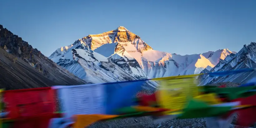
Most individuals assume the elevation of the world’s highest peak is a static figure found in a textbook, but the reality involves shifting tectonic plates, varying sea levels, and complex scientific debates. Grasping how tall is Mount Everest requires looking beyond a simple number and diving into the geological nuances that make this determination so difficult. For anyone planning a trek, studying geography, or just settling a trivia bet, knowing the precise altitude affects everything from oxygen calculations to historical records. This guide breaks down the measurements, the controversies, and the sheer scale of the monolith to provide a complete picture of its true stature.
Understanding the Height of Mount Everest
The vertical extent of this massive formation has been a subject of debate for nearly two centuries, with political borders and geological shifts playing a massive role. It is not just a rock sitting still; the giant is a growing, shifting entity pushed upward by the collision of the Indian and Eurasian tectonic plates. When people look for a definitive answer, they often stumble upon conflicting data from different decades.
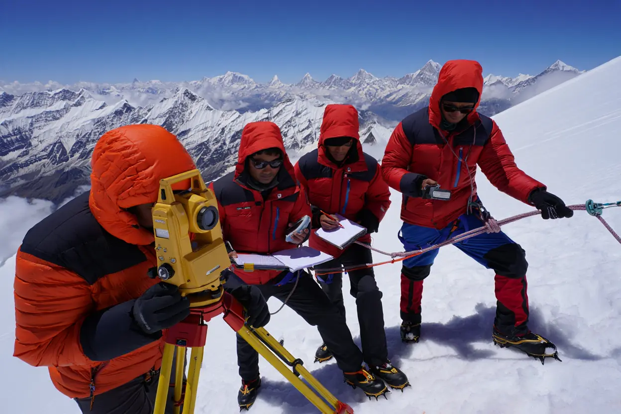
To truly grasp the scale, one must look at the most recent major update. In late 2020, a historic collaboration between Nepal and China established a new, universally accepted elevation. This agreement ended years of discrepancy where distinct nations recognized differing heights based on whether they included the snow cap or stopped at the bedrock.
Official Measurements and Updates
The most current official elevation is 29,031.7 feet (8,848.86 meters). This figure was announced jointly by Kathmandu and Beijing in December 2020. Before this accord, the Nepalese government stuck to the measurement of 8,848 meters (29,029 feet) derived from a 1954 Indian survey, while Chinese authorities often cited a rock-height figure of 8,844.43 meters (29,017 feet).
It is fascinating to see how science refines our understanding of the mountain. For example, during our own history on the peak, the official numbers were different. When Gary Guller made history as the first single-arm amputee to summit during the Team Everest ’03 expedition, he was operating under the 1954 survey data (8,848 meters). While the mountain has officially ‘grown’ by 86 centimeters since then, the challenge remains the same.
Important Note: This 2020 measurement is significant because it is the first time the two nations, which share the mountain, have agreed on a precise number using modern gravity surveys and global navigation satellite systems.
In a joint announcement presented on December 8, 2020, Nepal’s Survey Department and Chinese authorities agreed on an official elevation of 8,848.86 meters (29,031.69 feet), explicitly including the snow-and-ice cap and ending years of disagreement over “snow height” versus “rock height.” (2020, Nepal Survey Department & Chinese authorities)
Historical Changes in Measurements
The history of surveying this colossus is as dramatic as climbing it. In the mid-19th century, the Survey of India—one of the most ambitious scientific projects of the Victorian era—undertook the task of mapping the subcontinent. Led by Sir Andrew Waugh, the project utilized massive, half-ton theodolites to triangulate the peak from the Indian plains, over 100 miles away.
In 1856, the Survey’s Chief Computer, the brilliant Indian mathematician Radhanath Sikdar, calculated the altitude of what was then known as Peak XV to be exactly 29,000 feet. Legend suggests that Waugh added two feet—officially recording it as 29,002 feet (8,840 meters)—to prevent the public from assuming such a round number was merely a rough estimate. This measurement remained the gold standard for nearly a century, proving the incredible precision of manual trigonometric calculations.
From Theodolites to Satellite Geodesy
As technology evolved, so did our precision. In 1954, a survey by the Survey of India refined the height to 8,848 meters (29,029 ft), a figure that stood for decades. However, the introduction of Global Navigation Satellite Systems (GNSS) in the late 20th century sparked new debates. In 1999, an expedition sponsored by the National Geographic Society placed a GPS receiver on the summit, suggesting a height of 29,035 feet (8,850 meters).
While this figure was widely adopted by US cartographers, it lacked official recognition from Nepal and China due to differences in how the geoid model and snow-cap depth were calculated. This era of conflicting data highlighted a critical technical threshold: until surveyors could agree on a unified gravimetric geoid, the “true” elevation remained a matter of national and scientific perspective rather than a singular fact.
Factors Affecting Measurement Accuracy
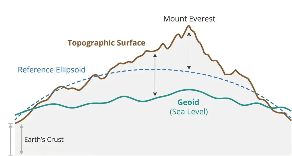
To determine Everest’s height, scientists must choose a reference surface. Using GPS/GNSS gives a height based on the Reference Ellipsoid—a smooth, idealized mathematical model of the Earth. However, this doesn’t account for the uneven distribution of Earth’s mass.
To find the “true” elevation above sea level, surveyors use the Geoid—a model of global mean sea level that accounts for gravity anomalies caused by the Himalayas’ immense mass. The difference between these two surfaces (known as Geoid Undulation) can exceed 20 meters in this region. The 2020 official height (8,848.86m) is so accurate because it utilized a high-resolution local gravity survey to align the satellite data with the physical geoid.
Snow Depth vs. Rock Height
One major variable is the ice sitting on top of the bedrock. The thickness of this frozen layer fluctuates seasonally with the monsoon. Modern surveys use Ground Penetrating Radar (GPR) to see through the glacial cover to the stone tip.
Atmospheric Refraction
When surveyors utilize optical instruments from miles away, the Earth’s atmosphere bends light. This refraction can distort calculations, making the summit appear higher or lower than reality.
In the context of geological time, precision is a moving target because the mountain is technically still growing due to tectonic pressure.

Mount Everest’s Height Above Sea Level
When discussing elevation, the standard metric is “above mean sea level.” This figure is what pilots, mountaineers, and cartographers care about most. It determines air pressure and oxygen availability, which are the critical factors for survival in the high-altitude environment.
When asking how tall is Mount Everest above sea level, one is essentially inquiring about the atmospheric conditions at the apex. At the summit (8,848.86m), the effective oxygen percentage remains 20.9%, but the barometric pressure drops to approximately 339 hPa (about 1/3 of sea-level pressure). This results in an inspired oxygen partial pressure (PiO2) of roughly 43 mmHg, which is the absolute physiological limit for human survival without supplemental oxygen for more than a few hours.
- Variables affecting readings:
- The model of the geoid (Earth’s shape) utilized for calculation.
- Local gravity anomalies that distort data.
- Tidal points taken from different oceans (e.g., Bay of Bengal vs. Yellow Sea).
- Seasonal fluctuations in precipitation on the peak.
Current Height in Meters and Feet
As established, the official altitude is 8,848.86 meters. For those more comfortable with Imperial units, understanding how tall is Mount Everest in feet is crucial for comparison with other peaks like Denali or Rainier. That equates to roughly 5.5 miles vertically into the sky.
Measuring the Climb
To understand the specific challenge for adventurers, knowing how tall is Mount Everest in feet helps visualize the acclimatization schedule. Alpinists don’t just ascend; they rotate up and down between camps to adjust to the altitude defined by this massive integer.
Comparing Measurements in Different Units
Different industries prefer distinct metrics. Aviation and US climbers stick to feet. The scientific community and most international bodies use meters. Occasionally, you might even see data converted to verify how tall is Mount Everest in cm for scientific precision regarding tectonic uplift.
| Measurement Unit | Value | Context |
| Feet | 29,031.7 ft | Aviation, Climbing (US) |
| Meters | 8,848.86 m | Scientific, International Standard |
| Kilometers | 8.848 km | General Geography |
| Miles | ~5.49 miles | Visualizing Distance |
This table highlights why confusion occurs. A slight rounding error when calculating how tall is Mount Everest in km might seem small, but in mountaineering, a few meters can determine line-of-sight and route safety.
Impact of Geological Activity on Height
The Himalayas are young structures. The Indian plate is still shoving underneath the Eurasian landmass, pushing the ranges up. However, earthquakes can have the opposite effect.
A 2015 paper in Science used high-rate GPS (5 Hz) and geodetic imaging to reconstruct how the Mw 7.8 Gorkha earthquake ruptured and how the Kathmandu basin amplified shaking—work that helped scientists quantify regional deformation, even though it was not designed to “re-measure” Everest’s summit elevation directly. (2015, AAAS/Science)
People often ask how tall is Mount Everest above sea level after major seismic events. While the 2015 disaster caused the ground around Kathmandu to rise, it resulted in a slight relaxation in the high Himalaya region.
From Base to Peak: Measuring Mount Everest
Here is a common point of confusion: “Highest” does not always mean “Tallest” in terms of vertical rise from the bottom. When people ask how tall is Mount Everest from base to peak, the answer is less impressive than its sea-level elevation.
Because the giant sits on the Tibetan Plateau, which is already incredibly elevated, the mountain’s prominence—its rise from the surrounding terrain—is different from its total altitude.
- Understanding the Base:
- Define the Bottom: Unlike a volcano rising from an ocean floor, this peak rises from a high tableland.
- Determine the Start Point: The north face starts from Tibet (around 17,000 feet).
- Calculate the Rise: The vertical gain is roughly 12,000 to 15,000 feet depending on the side.
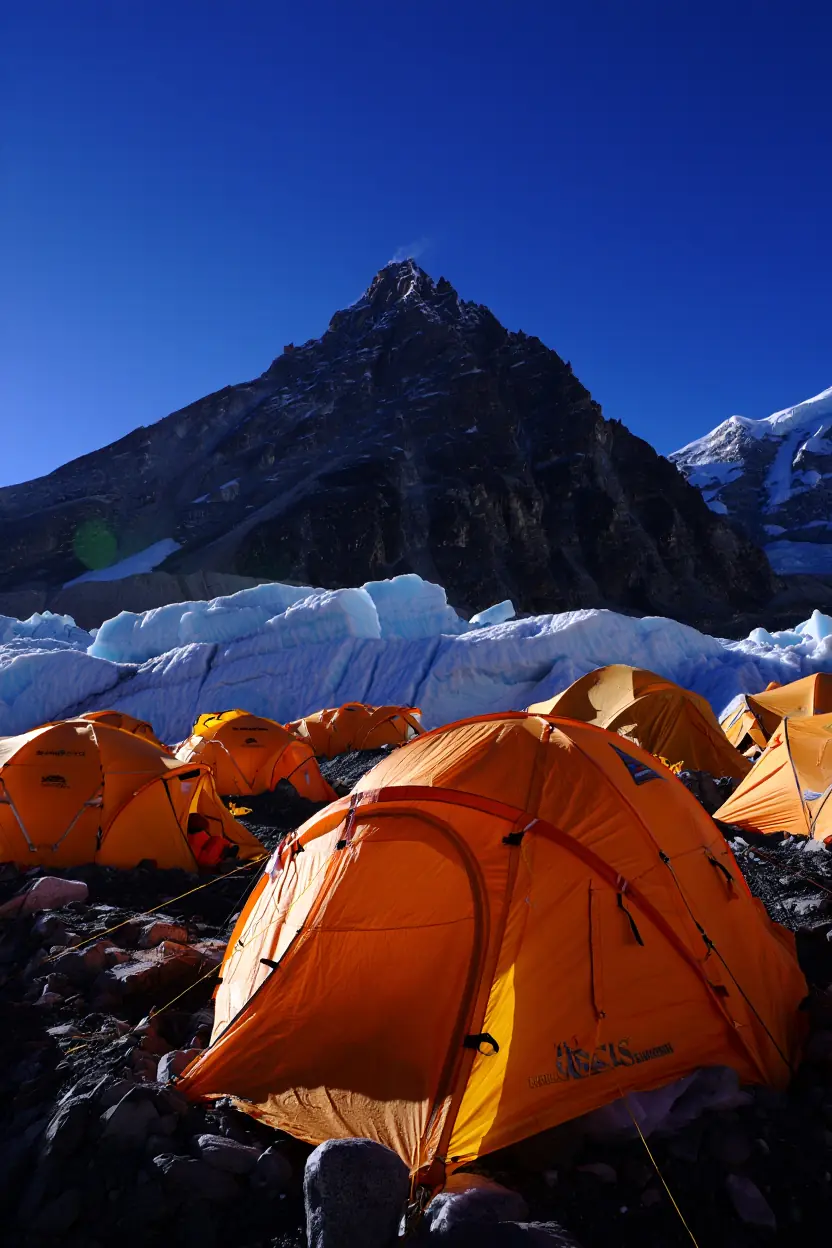
The Base Camp to Summit Journey
Adventures usually start from the camping grounds. On the south side (Nepal), the site is at 17,598 feet. When considering how tall is Mount Everest from base to peak for a climber, they are physically ascending about 11,400 feet of vertical slope. This is physically demanding, but it represents less vertical gain than climbing Mauna Kea from its ocean floor origin.
Challenges in Measuring Base-to-Peak Height
Determining how tall is Mount Everest from base to peak is tricky because there is no flat “bottom” to the structure. It merges into the Lhotse and Nuptse ridges.
Understanding why “highest above sea level” isn’t the same as “tallest from base to peak” depends on how geographers define a mountain’s base, prominence, and reference level. The video below gives a clear, general explanation of these measurement concepts so readers can visualize why Everest’s base-to-peak figure is less straightforward than its sea-level elevation.
Scientific Methods Used in Measurements
Scientists use triangulation and gravity meters to determine these figures.
Step-by-Step Modern Measurement:
- Gravity Survey: Researchers measure attraction at various points to calculate the sea-level baseline.
- GNSS Survey: Receivers are placed on the summit to record satellite signals.
- GPR Reading: Radar measures the depth of the snow to find the rock tip.
- Data Processing: Supercomputers combine gravitational and orbital data.
The complexity of determining how tall is Mount Everest from base to peak highlights that while it is the highest point on Earth, the formation is not the tallest standalone structure.
Converting Mount Everest’s Height
For students and researchers, having the data in various units is essential. Let’s break down the specific conversions and why they are asked.
Height in Centimeters
Precision matters in geology. When tracking tectonic plate movement, scientists measure how tall is Mount Everest in cm. The mountain exhibits a steady tectonic uplift of 3.5 to 5 mm per year; however, this net gain is often offset by episodic subsidence. For instance, during the 7.8 magnitude Gorkha earthquake in 2015, some sections of the Himalayas saw a vertical drop of up to 0.6–1 meter, proving that Everest’s height is a balance between constant pressure and sudden seismic release. The current official elevation is 884,886 centimeters.
Using this small unit allows researchers to track minute changes. If you track how tall is Mount Everest in cm over a decade, you might see a growth of 4-5 centimeters, barring any earthquakes.
Height in Kilometers
For astronomers or those looking at the atmosphere, knowing how tall is Mount Everest in km is useful. At 8.848 kilometers, the summit pokes into the stratosphere.
Commercial jets cruise between 10 and 12 kilometers. Understanding how tall is Mount Everest in km shows that the peak is just below the cruising altitude of a Boeing 747. This proximity to jet streams is why the summit experiences hurricane-force winds.
Height in Miles
For an American audience, the best way to visualize the scale is knowing how tall is Mount Everest in miles. It is roughly 5.5 miles high. Imagine stacking 20 Empire State Buildings on top of each other.
When flight planning or looking at visibility, pilots consider how tall is Mount Everest in miles to ensure safe clearance over the range. The “5.5 miles” figure is also a common benchmark in general trivia.
The Significance of Mount Everest’s Height
The specific number—29,031 feet—is more than just a stat. It defines the biological limits of humanity.
The height of Everest dictates the “Death Zone” (above 8,000 meters), where the human body can no longer acclimatize and slowly begins to die, making speed and timing the only safety nets.
Cultural and Geographical Importance
To the Sherpa people, the mountain is Chomolungma, “Goddess Mother of the World.” The height represents a spiritual proximity to the heavens. In Nepal, it is Sagarmatha. The question of how tall is Mount Everest is not just physical but spiritual.
Influence on Climbing Expeditions
The elevation dictates the gear. Because of how tall is Mount Everest above sea level, climbers require supplemental oxygen. The barometric pressure is so low that effective oxygen levels are 33% of what they are at sea level.
“At 29,028 feet up in the troposphere, so little oxygen was reaching my brain that my mental capacity was that of a slow child.” — Jon Krakauer, journalist and author; former contributing editor at Outsidemagazine (1997). Insert in the same location, replacing the existing Krakauer quote.
Mount Everest in Popular Culture
Movies like Everest (2015) focus heavily on the altitude. The dramatic tension relies on the audience understanding how tall is Mount Everest in feet and what that elevation does to the human body.
At extreme altitude, the body struggles to get enough oxygen to tissues, which is why acclimatization and recognizing altitude illness matters as much as technical climbing skill. The video below concisely explains what low oxygen does to the body and why symptoms can escalate quickly near the summit environment.
Frequently Asked Questions About Mount Everest’s Height
What is the Official Height of Mount Everest?
Yes, there is now a single official number. As of 2020, Nepal and China agree that it is 8,848.86 meters (29,031.7 feet). This settled a long-standing disagreement between the two nations regarding whether to count the snow layer.
How Has Technology Improved Measurement Accuracy?
Technology has moved from optical triangulation to satellite precision. In the past, surveyors had to rely on line-of-sight calculations from miles away. Now, they carry GPS receivers to the summit and use gravity meters to calculate sea level with extreme precision, refining how tall is Mount Everest in cm.
Why Do Measurements Vary?
Readings vary because the Earth isn’t a perfect sphere; it’s an oblate spheroid. Different countries use different mathematical models (geoids) to define “sea level.” Also, the snow on the summit changes depth due to wind and melting, altering how tall is Mount Everest from base to peak slightly from year to year.
Is Mount Everest the Tallest Mountain in the World?
No, if you measure from base to peak. Mauna Kea in Hawaii is taller when measured from its base on the ocean floor. However, when asking how tall is Mount Everest above sea level, the Himalayan giant is undisputed. It is the highest point on Earth, but the Hawaiian volcano is the tallest structure. While it is the highest above sea level, its true distinction is being the highest of the 14 global ‘eight-thousand-meter’ peaks, a club where every meter above 8,000 adds exponential risk to human life.
Does the Height Change Every Year?
Yes, slightly. Tectonic pressure pushes it up by millimeters, while earthquakes can cause it to sink. Erosion and snowmelt also play a role. So, while the official number is static for now, the physical answer to how tall is Mount Everest changes constantly in nature.
Extra Insights: Comparing Mount Everest with Other Peaks
To really understand the scale, we have to compare it.
Comparison with Other World Peaks
- K2: At 8,611 meters, it is shorter but often considered harder to climb.
- Chimborazo: If you measure from the center of the Earth, Chimborazo in Ecuador is “higher” because the Earth bulges at the equator.
- Mauna Kea: When considering how tall is Mount Everest from base to peak, Mauna Kea wins at over 33,000 feet total height (mostly underwater).
Notable Expeditions and Their Findings
Recent expeditions have focused on re-measuring to see if the mountain is shrinking. Scientists are constantly checking how tall is Mount Everest in km to monitor global geological health.
“Is it always going to be the perfect number? No. But it’s a good number.” — Alex Tait, geographer at the National Geographic Society (2021). Place this quote where the Hillary quote currently appears.
Future Research and Technological Advancements
Future surveys will likely use LIDAR and more advanced satellite imagery. We might eventually have a real-time dashboard showing how tall is Mount Everest in cm on a daily basis, fluctuating with the snowpack.
While numbers on a map provide coordinates, the true measure of the mountain is its ability to test the absolute limits of human physiology and engineering.
Over geologic timescales, plate-motion reconstructions indicate that India’s convergence with Asia slowed dramatically after collision, a shift that helps frame how long-term uplift rates in the Himalaya can evolve as boundary conditions change. (2010, University of Cambridge & collaborators)
Conclusion
Understanding how tall is Mount Everest involves more than memorizing a number like 29,031 feet. It requires an appreciation for the geological forces pushing the land up and the scientific rigor required to measure it. From the debate over snow depth to the differences in how tall is Mount Everest in miles versus kilometers, the altitude is a dynamic intersection of nature and math.
If you are fascinated by geography or planning an adventure, don’t stop at the numbers. Look into the history of the surveys and the brave individuals who carried heavy equipment to the top of the world just to get a reading.
If you are ready to dive deeper into the world of high-altitude geography, I have prepared a resource for you. Below is a downloadable “Mountaineering Metrics Checklist.” This document will help you understand the different unit conversions and physiological zones associated with these altitudes.

What do you think is the most impressive stat about Everest: the height above sea level or the vertical rise from the base? Leave a comment below!
Sources
- Mount Everest Is More Than Two Feet Taller, China and Nepal Announce (2020). National Geographic.
- China, Nepal Agree on Mt. Everest’s Height (2020). Voice of America.
- Mount Everest: China and Nepal Agree on New, Taller Height (2020). The Guardian.
- Slip Pulse and Resonance of the Kathmandu Basin During the 2015 Mw 7.8 Gorkha Earthquake, Nepal, Imaged With Space Geodesy (2015). Science (AAAS).
- Did Nepal Earthquake Change Mount Everest’s Height? (2015). National Geographic.
- India–Asia Collision and the Cenozoic Slowdown of the Indian Plate (2010). Journal of Geophysical Research.
- How Tall Is Mount Everest? (2021). National Geographic — quote by Alex Tait, Geographer, National Geographic Society.