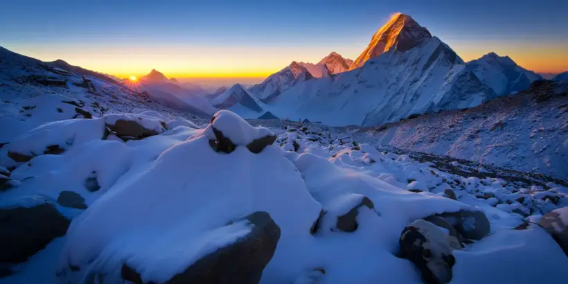
Standing at the absolute ceiling of the world, Mt Everest captures the human imagination not just as a geological formation, but as a testament to the raw power of nature and the limits of human endurance. For adventurers and dreamers alike, understanding this peak goes beyond merely knowing its altitude; it requires grasping the complex interplay of geography, climate, and culture that defines the region. Ignoring the realities of this mountain—whether one plans to climb it or simply admire it from afar—can lead to dangerous misconceptions about the preparation and respect required for such an environment. This comprehensive guide provides a deep dive into the physical and logistical realities of the massif, offering readers the insights needed to truly appreciate its grandeur. By the end, you will possess a structured understanding of the world’s highest point, separating myth from the cold, hard reality of the Himalayas.
Understanding Mt Everest: The World’s Tallest Peak
To truly grasp the significance of this mountain, one must look beyond the postcard images and understand the physical reality of its stature. The sheer scale of the landscape challenges standard comprehension, requiring a look at the specific metrics that define it. It is an environment where biological limits are tested, and geological history is written in the rock face itself.
The Height of Mt Everest in Feet and Kilometers
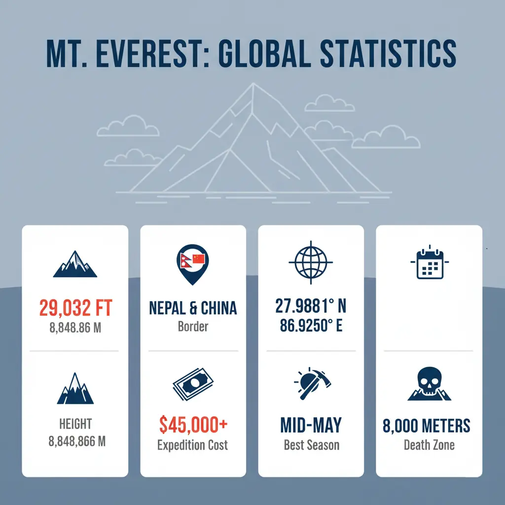
The elevation of the peak is the subject of constant scientific refinement and fascination. For Americans accustomed to imperial measurements, the Mount Everest height in feet sits officially at 29,032. This number is difficult to visualize, but imagine stacking roughly twenty Empire State Buildings on top of one another to reach the summit. Conversely, in the scientific community and most of the world using the metric system, the Mount Everest height km measurement is recorded as 8.8486.
Precision is key here. In 2020, Nepal and China jointly announced this new official elevation, settling years of debate regarding snow depth versus rock height. When reviewing topographic maps, you will see the Mount Everest height in feet listed prominently, serving as the ultimate benchmark for high-altitude achievements. Meanwhile, atmospheric scientists studying the thinning air at the summit rely on the Mount Everest height km data to calculate oxygen levels, which drop to about one-third of what is available at sea level.
Understanding these figures helps explain the “why” behind the difficulty. At this elevation, the atmosphere provides barely enough oxygen to keep a human alive at rest, let alone during strenuous activity.
- Metric Accuracy: Essential for aviation and scientific study regarding atmospheric pressure.
- Imperial Tradition: Used primarily in historical records and Western climbing literature.
- Geological Growth: The mountain continues to rise slightly due to tectonic pressure.
- Snow Variation: Seasonal snowfall can alter the exact tip of the summit by several feet.
Precision matters in high-altitude planning because even a difference of a few hundred feet can significantly alter the barometric pressure and available oxygen.
The Geological Formation of Mt Everest
The story of how this mountain came to be is a dramatic tale of continental collisions. Roughly 50 million years ago, the Indian tectonic plate crashed into the Eurasian plate, crumpling the landscape and forcing the seabed upward. This process is ongoing; the collision continues to push the Himalayas higher every year. While the Mount Everest height km figure seems static on paper, the rock itself is being slowly squeezed upward by these immense forces.
According to a peer-reviewed geologic study, Mount Everest’s summit limestones (the Qomolangma Formation) are Ordovician marine deposits—evidence that rocks now at the top of the world were originally formed in an ancient ocean environment (2009, Geological Society of America).
This geological violence creates a unique instability. The region is seismically active, meaning the landscape is constantly shifting, albeit slowly. The “Yellow Band,” a distinctive sedimentary layer visible near the top, serves as a marble stripe running through the dark rock, reminding climbers that they are stepping on an ancient ocean floor.
The Ongoing Tectonic Shift
The Indian plate is still driving northward at a rate of about 5 centimeters per year. This immense force does not just build mountains; it creates the devastating earthquakes that occasionally rock the region. Understanding this geology is vital for appreciating the temporary nature of the landscape—what seems eternal is actually in constant, violent flux.
Historical Expeditions and First Ascents
History is written by those who dare to step into the unknown. Early attempts to scale the massif were fraught with failure and tragedy, largely due to a lack of understanding regarding the Mount Everest height in feet and the physiological toll it takes. The British expeditions of the 1920s paved the way, with George Mallory and Andrew Irvine disappearing into the mist in 1924, leaving behind a mystery that endures to this day. Even they struggled with calculating the Mount Everest height in feet accurately with the barometers of that era.
“Well, we knocked the bastard off,” — Sir Edmund Hillary, New Zealand mountaineer and explorer; one of the first confirmed climbers to reach Everest’s summit (1953).
It wasn’t until 1953 that Hillary and Norgay officially stood on the roof of the world. Their success was built on the failures and lessons of those who came before them, utilizing better oxygen systems and logistical support.
Many early expeditions failed because they treated the climb as a battle against the mountain rather than a partnership with the environment. Modern climbers must learn that patience and timing are more valuable than brute strength.
Mt Everest on the Map: Location and Geography
Pinpointing the exact location of the mountain is the first step in planning any trip, whether virtual or physical. A common confusion arises regarding borders and access points, which dictates the logistics of travel. The massif does not belong to a single nation but serves as a natural wall between two major powers.
Mt Everest in Which Country: Nepal and China
One of the most frequent questions asked by travelers is Mount Everest in which country is actually located. The answer is not singular; the summit sits directly on the border between Nepal to the south and China (Tibet Autonomous Region) to the north. This geopolitical division means there are two main faces to climb or visit, each offering a distinct experience.
- Nepal (South Face): The most popular route, offering the iconic trek to Base Camp through the Khumbu Valley.
- China (North Face): Accessible by road, offering a different, starker view of the mountain from the Tibetan Plateau.
- Border Policies: Crossing between sides at the summit is strictly prohibited and heavily monitored.
- Permit Differences: Nepal issues individual permits, while China often requires group visas and has stricter medical restrictions.
When looking for Mt Everest on map applications, you will see the border line running precisely across the apex. Understanding Mount Everest in which country suits your travel style is vital: Nepal offers cultural immersion through trekking, while the Tibet side offers vehicular access to high altitudes.
Choosing Your Path: South vs. North Face
Deciding between the Nepal (South) and Tibet (North) sides is the most critical logistical decision an expedition team makes. While the South side is culturally rich and offers the classic trek through the Khumbu Valley, the North side provides a more accessible approach by vehicle, albeit with harsher wind exposure. The table below outlines the primary differences in costs, logistics, and success rates for a standard, full-service commercial expedition.
| Feature | South Col (Nepal) | North Ridge (China/Tibet) |
|---|---|---|
| Avg. Expedition Cost | $45,000 – $65,000+ | $40,000 – $55,000+ |
| Difficulty | High (Khumbu Icefall risks) | High (Windy, constant cold) |
| Success Rate | ~60% | ~50% |
| Access Strategy | 10+ day trek (acclimatization) | Vehicle access to Base Camp |
How to Locate the Mountain Correctly
Many people struggle to find the exact spot on a standard globe. Here is a simple way to orient yourself when looking for Mt Everest on map interfaces:
- Locate India: Find the Indian subcontinent on the map.
- Look North: Move your eyes north to the long, white curve of the Himalayas.
- Find the Curve: Identify the border where Nepal creates a rectangle shape pressed against China and spot Mt Everest on map markers near the center.
- Pinpoint the Border: The peak is located in the Mahalangur Himal sub-range of the Himalayas. On a digital Mt Everest on map tool, search for coordinates 27.9881° N, 86.9250° E.
The Himalayan Mountain Range
The Himalayas act as a massive barrier separating the Indian subcontinent from the Tibetan Plateau. This range contains not just Mt Everest, but over fifty mountains that exceed 7,200 meters. The density of high peaks here is unmatched anywhere else on Earth. It creates a weather system of its own, blocking the monsoon rains from reaching Tibet, which creates the dry plateau to the north. When you trace the ridge lines of Mt Everest on map visualizations, you can see how it connects directly to Lhotse.
To visualize the sheer scale of this range and where the mountain sits within it, watching a high-quality topographical breakdown is incredibly helpful. It puts the prominence of the peak into perspective against its massive neighbors.
Before we talk about nearby peaks and route geometry, it helps to see Everest in motion—how the ridgelines connect and where Lhotse and Nuptse sit relative to the main summit. This short 3D flyover makes the spatial relationships far easier to understand than a static map.
Nearby Peaks and Notable Features
Surrounding the main peak are other giants that climbers often use for training or acclimatization. Lhotse (4th highest) and Nuptse form a massive horseshoe shape with the main summit, creating the “Western Cwm,” a valley of silence that climbers must traverse. Recognizing these features on a Mt Everest on map layout helps in understanding the climbing routes. It is also important for verifying Mount Everest in which country the specific subsidiary peaks lie, as some ridges cross international lines.
To the east stands Makalu, a pyramid of rock, and to the west lies Cho Oyu, often considered the easiest 8,000-meter peak. These giants are not just scenery; they buffer the winds and create the specific microclimates that climbers must navigate.
The Western Cwm and Lhotse Face
The Western Cwm is a glacial valley that acts as a solar oven. Despite the surrounding cold, the reflection of the sun off the white walls can raise temperatures to unbearable levels during the day. Following this, climbers must ascend the Lhotse Face, a sheer wall of blue ice that guards the upper reaches of the route.
Climbing Mt Everest: Challenges and Preparations
Climbing this mountain is an endeavor that requires years of preparation and significant financial investment. It is not merely a hike; it is a logistical operation involving government bureaucracy, extreme physiology, and risk management.
Required Permits and Legal Considerations
Bureaucracy is the first hurdle. The government of Nepal requires a climbing permit, which currently costs $11,000 per person, not including the liaison officer, trash deposit, and agency fees. This revenue is crucial for the local economy.
- Processing Time: Permits can take weeks to process in Kathmandu.
- Medical Forms: Strict medical reports are now required to prove fitness and health history.
- Insurance: High-altitude rescue insurance is mandatory and must cover helicopter extraction.
The question of Mount Everest in which country you choose to climb from affects the price and regulations. Confirming Mount Everest in which country your expedition is based determines if you are subject to the Nepal Tourism Board or the China Tibet Mountaineering Association.
Physical and Technical Challenges
The physical toll of the climb is immense. Aspiring climbers must achieve a VO2 max of at least 50-60 ml/kg/min and be capable of maintaining a steady uphill pace with a 20kg pack for 6-8 consecutive hours. General cardio is insufficient; you need to simulate ‘weighted step-ups’ to prepare for the 30-degree to 45-degree inclines encountered on the Lhotse Face. Every vertical meter matters, and the sheer verticality represented by the Mount Everest height km stat forces a slow, methodical ascent.
- Cardiovascular Endurance: The heart must work double time to pump oxygen-rich blood.
- Strength Training: Legs and core must carry heavy packs up steep ice.
- Mental Resilience: The ability to suffer for weeks without giving up.
- Technical Skills: Proficiency with crampons, ascenders, and crossing ladders is non-negotiable.
Essential High-Altitude Gear
Surviving the Death Zone requires specialized equipment rated for extreme environments. Standard outdoor gear is insufficient here; climbers must utilize:
- 8,000m Down Suit: A one-piece, high-loft down suit rated for temperatures as low as -40°C.
- Triple Boots: A multi-layered boot system (inner liner, insulated boot, and outer shell/gaiter) to prevent frostbite.
- Category 4 Sunglasses/Goggles: Essential to prevent snow blindness due to extreme UV exposure at high altitudes.
- Oxygen System: A lightweight mask and regulator system designed for high-flow oxygen delivery.
The Death Zone Reality
Above 8,000 meters, human life is unsustainable. Digestion slows, the mind clouds, and the risk of edema (fluid in lungs or brain) skyrockets. In the Death Zone, most climbers require a supplemental oxygen flow rate of 2 to 4 liters per minute to maintain cognitive function. Even with O2, the body cannot process nutrients effectively, meaning you have a strict 16-to-24-hour window to summit and descend before extreme exhaustion or HACE (High Altitude Cerebral Edema) becomes a 70% probability. Comparing the physiological effects at sea level versus the Mount Everest height in feet near the summit reveals that VO2 max drops by over 70%.
Geological Updates: The Status of the Hillary Step
The iconic Hillary Step—a 12-meter near-vertical rock face—historically served as the final major technical hurdle before the summit. Following the massive 2015 Nepal earthquake, reports from experienced guides suggest the feature has changed significantly, with the original rock structure potentially buried under a more accessible, albeit unstable, snow slope. Climbers should no longer expect the original technical rock climb; instead, the route is now defined by fluctuating snow conditions that shift annually.
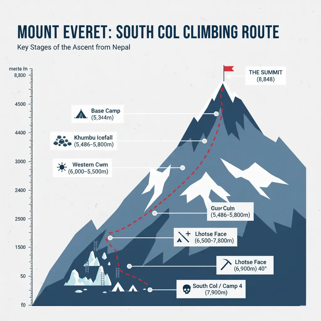
Popular Climbing Routes and Base Camps
There are two main highways to the top. The South Col route from Nepal is the most famous. It involves navigating the treacherous Khumbu Icefall. The North Ridge route from Tibet is colder and windier but avoids the icefall.
When studying the Mt Everest on map projections for climbing routes, one can see the distinct camps:
- Base Camp: The logistics hub where climbers spend weeks acclimatizing.
- Camp 1 & 2: Acclimatization zones located in the Western Cwm.
- Camp 3: Perched precariously on the Lhotse Face, carved into the ice.
- Camp 4: The launchpad for the summit push, located in the Death Zone.
Climbers must constantly reference their altitude against the total Mount Everest height in feet to manage their oxygen supplies for the return trip.
The summit is only halfway. Never expend more than fifty percent of your energy reaching the top, because the descent requires equal focus and often occurs in deteriorating weather conditions.
The Impact of Climate and Weather on Mt Everest
The weather on the mountain dictates everything. The height of the mountain penetrates the stratosphere, meaning the peak is subject to jet stream winds that can reach hurricane force. A clear day can turn into a lethal storm in minutes.
Seasonal Weather Patterns
For commercial expeditions focused on the South Col route, the primary summit window is restricted to a 10-to-14 day period in mid-May. However, elite alpine-style teams may attempt the peak in late September during the post-monsoon window, provided they can manage shorter daylight hours and a 20% higher risk of deep-snow avalanches. This is when the jet stream pushes north, calming the winds before the monsoon rains arrive from the south.
| Season | Wind Conditions | Precipitation | Climbing Viability |
| Winter (Dec-Feb) | Extreme (Jet Stream active) | Low snow, high wind | Very Low (expert only) |
| Spring (March-May) | Moderate to Calm | Moderate | High (Primary Season) |
| Monsoon (Jun-Aug) | Low Wind | Heavy Snow/Rain | Low (Avalanche risk) |
| Autumn (Sep-Nov) | Increasing Wind | Moderate Snow | Medium (Short days) |
This table illustrates why May is the busiest month. The convergence of manageable wind and acceptable snow levels creates the only realistic opportunity for most commercial expeditions.
During winter, the Mount Everest height km altitude exposes the peak to jet stream winds exceeding 200 mph, making it virtually unclimbable. Meteorologists often look at Mt Everest on map isobars to predict these windows.
Climate Change Effects on the Mountain
The mountain is changing rapidly. Rising global temperatures are causing the Khumbu Glacier to melt and recede, destabilizing the route through the Icefall. This makes the route more dangerous for the Sherpas who must maintain it.
According to a 2022 study in npj Climate and Atmospheric Science (Nature Portfolio), modeling and field observations suggest the South Col Glacier could experience ~55 m water-equivalent thinning over ~25 years once underlying glacier ice is regularly exposed—an implied rate more than 80× faster than the millennia-scale formation of the ice now at the surface (2022, University of Maine Climate Change Institute / Perpetual Planet Everest Expedition).
This melting reveals trash and bodies from past decades, creating a grim reminder of the mountain’s history. The Mount Everest height km implies a frozen permanence, but the ice itself is fragile and fleeting.
Safety Precautions for Climbers
For those attempting the climb or even the trek, weather safety is paramount. Ignoring the forecast can be fatal.
- Monitor the Forecast: Use specialized mountain weather services, not generic apps.
- Respect the Turnaround Time: Usually 2:00 PM on summit day is the hard cutoff.
- Layering System: Ensure gear is rated for -40 degrees Fahrenheit.
- Hydration: Dehydration accelerates altitude sickness significantly.
Climbers constantly monitor the Mount Everest height in feet pressure levels. A drop in barometric pressure effectively increases the physiological altitude, making the air feel even thinner than it already is.
Cultural and Environmental Significance of Mt Everest
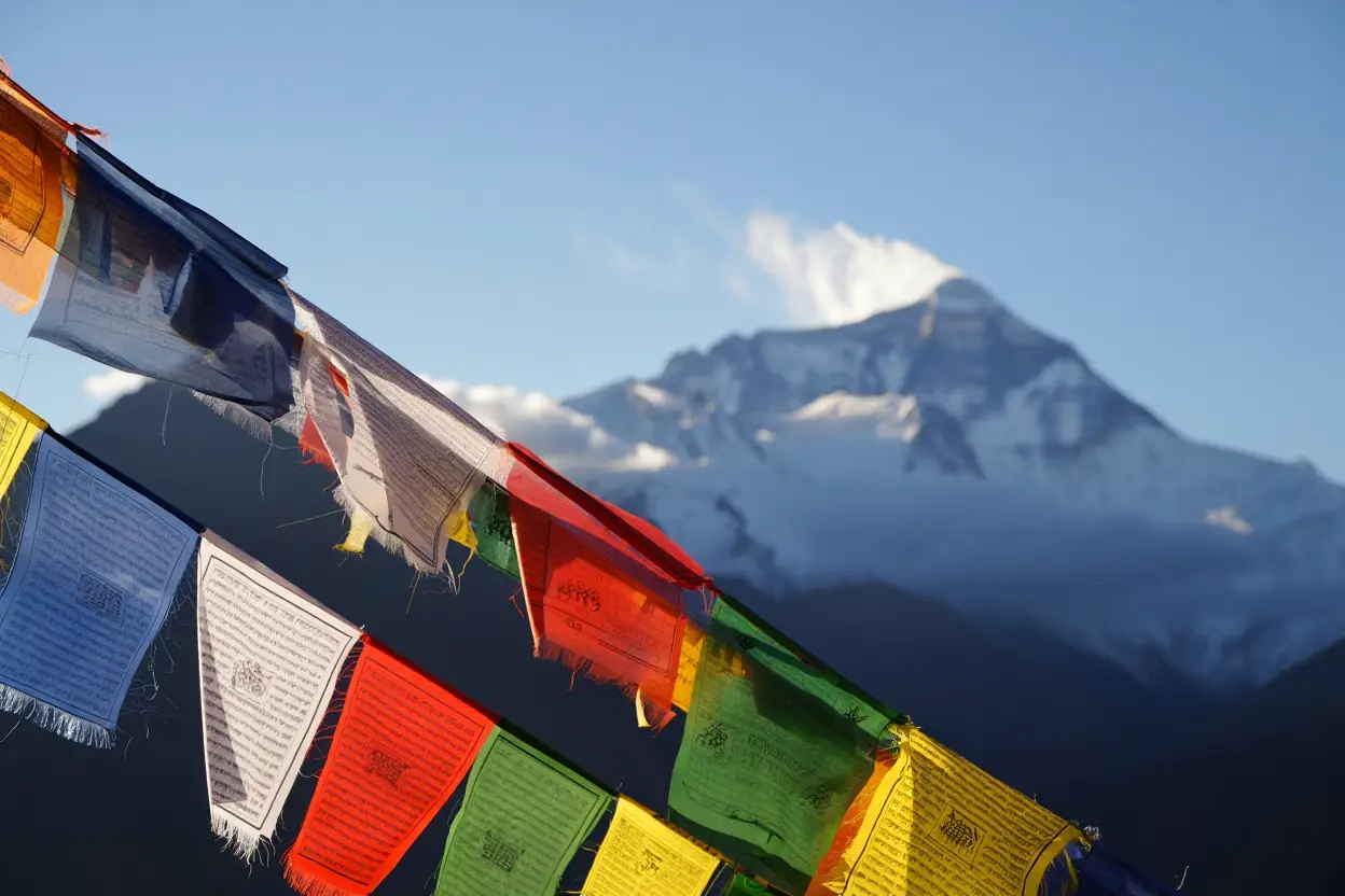
The mountain is known locally as Sagarmatha in Nepali and Chomolungma in Tibetan. It is a sacred entity, not just a sporting arena. Understanding this cultural depth is essential for any visitor. The Sherpa people believe the mountain is the abode of Miyolangsangma, the goddess of inexhaustible giving.
The Sherpa Community and Their Role
The Sherpa people are the backbone of all expeditions. They are an ethnic group with a unique genetic adaptation to high altitude. Often mistakenly used as a job title for “porter,” Sherpa is actually a distinct culture and lineage. Their biological advantage allows them to work harder with less oxygen than their western counterparts.
“These expeditions wouldn’t happen without them. They’re the backbone of all the organizations up here,” — Gavin Turner, Australian climber (quoted by ABC News). (2014)
When visiting, knowing Mount Everest in which country you are in dictates the cultural etiquette. On the Nepal side, Buddhism prevails, and prayer flags flutter from every bridge and stupa. Regardless of Mount Everest in which country the expedition starts, respecting local customs is mandatory.
Mt Everest’s Ecological Importance
The mountain acts as a “water tower” for Asia. The glaciers feed major rivers that support billions of people downstream. However, the influx of tourists has created an ecological crisis. The “Leave No Trace” principle has been historically ignored, leading to piles of debris at Camp 4.
- Waste: Human waste and oxygen bottles litter the high camps.
- Water Security: Pollution at the source affects downstream communities.
- Ecosystem Balance: The Mt Everest region supports rare species like the snow leopard and Himalayan tahr.
Efforts in Conservation and Sustainability
There are massive efforts underway to clean the mountain. The Sagarmatha Pollution Control Committee (SPCC) manages the “Icefall Doctors” and monitors trash removal. Expeditions are now required to bring down their trash and human waste, with heavy fines for non-compliance.
Everest’s cleanup work isn’t a feel-good side story—it’s a dangerous, physical operation carried out in extreme altitude where every minute costs energy and oxygen. The video below shows how cleanup teams operate in the so-called “death zone” and why removing legacy waste is so hard.
Leave no trace is not just a suggestion; it is a requirement. If you pack it in, you must pack it out. This applies to everything from candy wrappers to biological waste.
Planning Your Visit to Mt Everest
You do not have to be a climber to experience the majesty of the Himalayas. Trekking to Base Camp is a bucket-list item for thousands of hikers annually. It offers the visual splendor without the death-defying risks of the summit push.
Travel Tips and Best Times to Visit
To get there, most travelers fly into Kathmandu, Nepal. From there, a thrilling flight to Lukla starts the journey.
- Visas: Obtain a tourist visa upon arrival in Nepal (bring passport photos).
- Permits: You need a TIMS card and a National Park permit.
- Cash: ATMs are scarce in the mountains; carry plenty of Nepali Rupees.
- Connectivity: Buy a local Ncell or Nepal Telecom SIM card in Kathmandu.
Since Mount Everest in which country spans two nations, you could also fly to Lhasa, Tibet, and drive to the North Base Camp. This requires a Chinese visa and a special Tibet Travel Permit. Checking Mt Everest on map routes will show that the Tibet side is a road trip, while the Nepal side is a classic foot trek. Modern digital Mt Everest on map tools can help you visualize the daily distances.
Practical Application Checklist
- Check your passport validity (must be 6 months).
- Book international flights 6 months in advance.
- Start cardio training 3 months prior.
- Purchase travel insurance that covers altitude (World Nomads or Global Rescue).
- Break in your hiking boots one month before departure.
- Buy a printed Mt Everest on map guide for backup navigation.
Nearby Attractions and Activities
While the Mount Everest height in feet (29,032) is the main draw, the region offers much more.
- Gokyo Lakes: A stunning alternative trek with turquoise lakes that avoids the crowds.
- Tengboche Monastery: The spiritual center of the Khumbu, where climbers receive blessings.
- Namche Bazaar: The bustling Sherpa capital, shaped like a horseshoe in the hillside.
Evidence from controlled altitude-staging research shows that taking a structured “staging” break of about two days at moderate altitude (around 3,000–3,500 m) can meaningfully reduce the incidence of Acute Mountain Sickness during subsequent ascent (2018, U.S. Army Research Institute of Environmental Medicine).
Health and Safety Considerations
Altitude is the great equalizer. Whether you are looking at the Mount Everest height km data or feeling it in your lungs, the air is thin. Acute Mountain Sickness (AMS) can strike anyone, regardless of fitness.
- Acclimatization: Strict adherence to the “climb high, sleep low” philosophy.
- Hydration: Drink at least 4 liters of water daily.
- Medication: Carry Diamox (Acetazolamide) but consult a doctor first.
- Hygiene: Eat only cooked food to avoid stomach bugs which are common.
Tracking your elevation relative to the Mount Everest height in feet benchmarks on your map is a good way to pace yourself. Similarly, keep in mind the Mount Everest height km vertical gain per day should not exceed 500 meters once above 3,000 meters.
FAQ
How much does it actually cost to climb Mt Everest?
Yes, it is very expensive. For a standard supported climb on the South side, a budget of $45,000–$65,000 is the baseline for safe logistics. If you are a first-time 8,000m climber, avoid ‘budget’ operators charging under $35,000, as these often lack sufficient backup oxygen cylinders and experienced 1:1 Sherpa-to-client ratios necessary for survival during bottleneck delays at the Hillary Step.
Is it possible to see Mt Everest without trekking for weeks?
Yes, absolutely. You can take a scenic mountain flight from Kathmandu that flies along the Himalayan range and returns in an hour. Alternatively, on the Tibet side, you can drive all the way to the Rongbuk Monastery, which offers a clear view of the North Face without any hiking.
What is the “Death Zone” I keep hearing about?
The Death Zone is any altitude above 8,000 meters (approx 26,247 feet). At this height, the oxygen pressure is insufficient to sustain human life for long periods, and the body begins to die cell by cell. Climbers must minimize their time here to survive.
Does the height of the mountain change?
Yes, it does. Tectonic activity pushes the mountain up by a fraction of an inch each year. However, strong earthquakes, like the one in 2015, can cause it to sink slightly or shift, leading to the need for periodic re-measurement by scientists.
Can I use my credit card at Base Camp?
No, generally not. While some lodges in lower villages like Namche Bazaar accept cards (often with a high fee), once you get closer to Base Camp, cash is king. Always carry enough Nepali Rupees to cover your food, drinks, and tips for the duration of the trek.
Conclusion
Mt Everest remains one of the most compelling destinations on Earth, offering a unique blend of extreme physical challenge and profound spiritual beauty. Whether you are an aspiring alpinist or an armchair traveler, the mountain demands respect. It is a place where political borders—raising the question of Mount Everest in which country it belongs—fade away in the face of nature’s raw power.
If this guide has sparked a desire to see the roof of the world, start by assessing your fitness and researching the trek to Base Camp. Do not just dream about it; look at your calendar and see when you might be able to carve out two weeks for the adventure of a lifetime. Start walking, start planning, and perhaps one day you will see the sunrise hitting the summit with your own eyes. For those ready to take the next practical step in planning their expedition or trek, I have prepared a comprehensive resource to keep you organized.
Would you like to download the “Everest Expedition & Trekking Readiness Checklist” to ensure you haven’t missed a single detail in your preparation?

Which face of the mountain—North or South—appeals to you more? Let me know in the comments below!
Sources
- Stratigraphic correlation of Cambrian–Ordovician deposits along the Himalaya: implications for the age and tectonic evolution of the Mount Everest region — 2009 (Geological Society of America).
- Mt. Everest’s highest glacier is a sentinel for accelerating ice loss — 2022 (University of Maine Climate Change Institute / Perpetual Planet Everest Expedition).
- Acute Mountain Sickness is Reduced Following 2 Days of Staging During Subsequent Ascent to 4300 m — 2018 (U.S. Army Research Institute of Environmental Medicine).
- Hillary, E. (2003). The Guardian — 2003 (primary interview quoted).
- Turner, G. (2014). ABC News — 2014 (interview/quote in report).